

BIM and GIS at IIIC: Choosing the Right Digital Construction Career Path

You are kindly requested to fill out this form and select the course at IIIC that interests you so that we may get in touch with you as soon as admissions are open.
Anyone comparing a building information modeling course india option against a spatial data programme is really comparing two different digital disciplines that happen to share an industry. One describes a single building in three dimensions. The other describes everything around it across a landscape. IIIC teaches both, at more than one tier, and this hub exists to help you choose rather than to repeat any single programme page.
Key Takeaways
- Building modelling works at the scale of one asset: geometry, systems, quantities and clash free coordination for a specific project.
- Spatial data works at the scale of terrain and networks: where things are, how they relate, and what that means for planning, alignment and asset management.
- IIIC runs modelling at both the six month diploma tier and the one year postgraduate tier, and spatial data at the diploma tier, with internships attached to both disciplines.
- Your existing degree narrows the choice more than your interest does, so check eligibility before you fall in love with a subject.
Two Digital Disciplines That Get Confused With Each Other
The confusion is understandable. Both disciplines involve three dimensional data, both sit on a computer, and both are marketed to the same civil engineering graduates with similar promises about digital construction careers.
The difference is scale and purpose. Building information modeling produces a coordinated digital model of one asset, rich enough that quantities, clashes and sequencing can be read off it before anything is built.
Geographic information systems instead handle positional data across an area: terrain, boundaries, networks, land use and the analysis that turns those layers into a decision about where something should go.
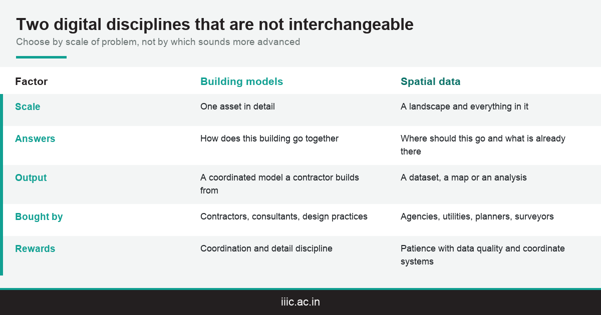
A useful shorthand is that modelling answers how this building goes together, while spatial data answers where this should be and what is already there. Both are digital construction. They are not interchangeable careers.
The employers differ too. Modelling skills are bought mainly by contractors, consultants and design practices working on buildings. Spatial data skills are bought by infrastructure agencies, utilities, planning bodies, surveying firms and increasingly by environmental and asset management teams.
Getting this distinction right before you enrol is worth six months of your life, because the two skill sets are not close enough that one substitutes for the other in a hiring conversation.
The confusion is not helped by how both are marketed. Training providers tend to sell software names rather than disciplines, and a course advertised on the strength of one application tells you almost nothing about which of these two career paths it genuinely prepares you for.
A simple test cuts through most of it. Ask what the output of the work is. If the answer is a coordinated model of one building that a contractor will build from, that is one discipline. If it is a map, an analysis or a dataset covering an area, that is the other one.
What Building Modelling Actually Does on a Project
A model is not a drawing that happens to be three dimensional. It is a database with geometry attached, and that distinction is the whole point of the discipline.
Because each element carries information, the model can be interrogated. Quantities can be extracted, clashes between structure and services can be found before anyone is on site, and a construction sequence can be tested against a programme.
That is where the commercial value sits. A clash found on a screen costs an hour. The same clash found on site costs rework, delay and often an argument about who pays for it, which is why clients increasingly write modelling requirements into contracts.
Interoperability matters as much as any single tool. Open exchange formats such as IFC exist so that a model produced by one discipline can be read by another without everyone standing on the same software licence.
IIIC has written about the discipline itself at some length. The primer on digital construction models covers what modelling is, and IIIC’s professional modelling training guide covers how the institute teaches it.
Read both if the subject is new to you. This hub assumes you broadly know what a model is and are trying to work out which programme tier to enter it through.
One thing worth understanding early is that modelling is a process discipline as much as a technical one. Somebody has to decide what information goes into the model, at what stage and to what level of detail, and that governance work is where the postgraduate tier spends much of its extra time.
This is also why modelling roles have split in practice. Producing geometry accurately is a valuable and learnable skill, while running a modelling process across several consultants and contractors is a different job that requires the same technical base plus a coordination mindset.
What Spatial Data Actually Does on a Project
Spatial data starts with position. Every feature has a location, and the discipline is about capturing, cleaning, storing and analysing those locations so that a question about a place can be answered with evidence.
For infrastructure that shows up early. Route alignment for a road, catchment analysis for drainage, land acquisition boundaries and utility corridor mapping are all spatial questions that must be settled before design work is worth starting.
It shows up late as well. Once assets exist, somebody has to know where they are, what condition they are in and which of them a given failure affects, which is why utilities and municipal bodies are steady employers in this field.
Remote sensing sits alongside this as the capture side of the same discipline, using satellite and aerial imagery to build the layers that analysis then works on.
The software landscape is split between commercial platforms such as ArcGIS and open source tools such as QGIS, and competent practitioners tend to be comfortable in both rather than loyal to either one.
IIIC publishes a career oriented guide to this side of the industry as well. The GIS career guide covers scope and progression, and IIIC’s remote sensing programme guide covers the capture discipline specifically.
The part applicants underestimate is data quality work. Most spatial projects spend more time cleaning, aligning and validating layers than producing the final analysis, and a practitioner who is careless at that stage produces confident looking output that is quietly wrong.
That is also the reason the discipline suits a particular temperament. It rewards patience with detail, comfort with coordinate systems and a willingness to check assumptions, more than it rewards visual flair or speed, which is worth knowing before you choose it.
IIIC’s Digital Routes at a Glance
IIIC runs nineteen programmes across three tiers, and the digital disciplines appear at more than one of them. That is not duplication. Each tier has a different entry bar and points at a different level of role.
Two things are worth checking on every programme page before you shortlist: the eligibility rule, which is what actually decides whether a route is open to you, and the current intake dates, which move between cycles.
Seats are capped at forty per programme at both the diploma and postgraduate tiers, and popular specialisations can close before a published deadline, so early application is the practical default rather than an optimisation.
The admission sequence itself takes time too. An online application is followed by the ATEiiic entrance assessment, a group discussion and a personal interview, which together usually run to several weeks rather than a few days from first enquiry to a confirmed seat offer.
The internships attached to both disciplines are the part applicants most often miss, and they matter because they are what convert software familiarity into something an employer will treat as evidence.
One further point applies across all three routes below. Every one of them sits on the same 9.2 acre campus at Neendakara in Kollam, draws on the same labs and the same placement office, and carries the same institutional accreditation, so the choice between them is genuinely about fit rather than about quality.
The six month modelling diploma
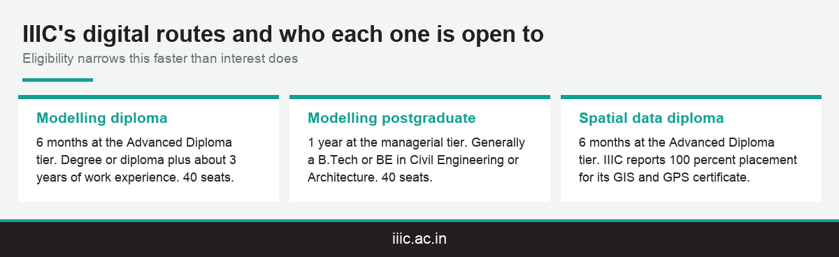
The Advanced Diploma in building information modelling sits in IIIC’s eight programme diploma tier, running six months with eligibility built around a relevant degree or diploma plus roughly three years of work experience. Current terms are on the AD BIM programme page. It suits somebody already working who needs a named credential in the discipline.
The one year postgraduate modelling route
At the managerial tier sits a one year postgraduate programme, which generally requires a B.Tech or BE in Civil Engineering or Architecture at entry. Details sit on the PGP BIM programme page. The additional six months buys the management layer: coordinating a modelling process across disciplines rather than producing models within one.
The six month spatial data diploma
Spatial data is taught at the diploma tier through the Advanced Diploma in geographic information systems, listed on the AD GIS programme page. IIIC also reports a hundred percent placement rate for its GIS and GPS certificate programme, which is the strongest published figure across the institute.
Which Route Your Background Actually Points To
Interest is a poor first filter, because most applicants find both disciplines genuinely interesting once they understand them. Eligibility is a much better one, and it narrows the field quickly.
The second filter is temperament, and it is worth taking seriously. These two disciplines reward different habits of mind, and people tend to be noticeably happier in one than the other once the novelty wears off.
The third is where you want to work geographically, since the employer mix differs. Modelling follows building projects; spatial data follows agencies, utilities and infrastructure programmes that are more evenly distributed.
If you are genuinely torn after all three filters, the shorter diploma is the lower risk experiment, and IIIC’s tier structure is deliberately built so that returning later at a higher tier stays realistic.
What follows is a rough mapping from common starting points rather than a rule. Treat it as a prompt for the conversation you have with the admissions team, who can speak to programme fit against your specific qualification far better than any article can in the abstract.
Coming from civil engineering or architecture
Both routes are open to you, and the postgraduate modelling tier is open only to you, since it asks for exactly this degree. If you enjoy the detail of how a building goes together, modelling is the natural fit. If you found the planning and alignment side of your degree more interesting than the structural detail, spatial data may suit you better than the obvious choice does.
Coming from geography, planning or surveying
The postgraduate modelling tier will generally be closed to you on eligibility, which simplifies the decision considerably. The spatial data diploma is the natural home for this background, and it builds directly on the coordinate systems, projections and survey logic you already have rather than starting from zero.
Coming from drafting or a trade background
The diploma tier is the realistic entry point, and the experience requirement usually works in your favour rather than against you. IIIC also runs a shorter option in the drafting and visualisation certificate, which is worth considering as a first step if the three year experience rule is not yet met.
Software, Standards and What Employers Actually Test
Applicants ask about software first and standards last. Employers test in roughly the opposite order once you are past a first screening, which is worth knowing before you choose a programme on its tool list alone.
On the modelling side, the tool question usually reduces to whether you can work in a mainstream authoring environment and, more importantly, whether you can run and interpret a coordination review rather than only build geometry.
On the spatial data side, it reduces to whether you can build a clean dataset. Projections, coordinate systems, topology and attribute discipline are what separate usable analysis from a map that looks convincing and is quietly wrong.
Standards literacy is the layer above both. Knowing how information is meant to be structured and exchanged is what lets a graduate work inside somebody else’s process rather than only their own.
Practical hours are the honest proxy for all of this. IIIC puts the hands on share of its training at roughly seventy five percent, and facilities such as the computer centre and the advanced survey lab are where that time is actually spent.
The internships are the final proof point. Ask specifically about the modelling internship and the spatial data internship when you speak to admissions, because portfolio evidence is what employers actually interview against.
A useful question to ask any provider is what a student leaves with. A certificate alone is thin. A certificate plus a coordinated project you can talk through, or a dataset and analysis you built end to end, is what actually gets discussed at interview.
It is also worth asking how assessment works. Programmes that assess on a real project rather than a written paper tend to produce graduates who can do the work, because the assessment itself forces the practical problem solving that the job consists of.
Where the Two Disciplines Overlap and Why That Matters
The clean separation above is useful for choosing, but it understates how much the two fields have converged over the last decade, and that convergence is worth understanding as a career hedge.
Large infrastructure projects increasingly need both at once. A highway or a metro line is a linear asset in a landscape, which means alignment, terrain and land data on one side and detailed structural and services models on the other.
Asset management is the other meeting point. Once a project completes, the client wants to know both what was built and where it sits, which is a question neither discipline answers fully on its own.
The practical implication for a student is that a working knowledge of the other side is a genuine differentiator. You do not need dual expertise, but being able to hold a sensible conversation across the boundary makes you more useful on exactly the large projects that pay best.
This is also an argument for the tier structure rather than against it. A diploma in one discipline followed by working exposure to the other is a common and effective path, and it is cheaper than attempting both formally at once.
What it is not is an argument for choosing badly on the grounds that the fields overlap. Your first credential is what gets you interviewed, and it needs to match the roles you intend to apply for.
Kerala offers a reasonable illustration of the convergence. Coastal highway work, urban drainage and utility upgrades all involve landscape scale questions and detailed asset design in the same programme of work, often for the same client.
Anyone who ends up coordinating across that boundary tends to become valuable quickly, because the number of people who can hold both conversations credibly is small relative to the number of projects that now need them to happen.
Accreditation, Placement and Verifying Any Claim
Digital construction is a crowded training market, and it is one where claims are easy to make and hard to check. Four things can actually be verified before you pay anybody, and they are worth checking at every institute you shortlist.
First, affiliation. IIIC is affiliated with the National Skill Development Corporation across thirteen sectors and separately with the Construction Skill Development Council of India, with both listed on IIIC’s accreditation and affiliation page.
Second, institutional backing. IIIC operates as a Centre of Excellence under the Kerala Academy for Skills Excellence and is managed in partnership with ULCCS, a worker cooperative active in Kerala infrastructure since 1925. It is also the only Training of Trainers centre in the state.
Third, published outcomes at programme level. IIIC reports ninety five percent for advanced construction management, ninety two percent for urban planning design and management, and a hundred percent for the GIS and GPS certificate programme, with more than fifty recruiting organisations across the institute.
The placement outcomes page carries the current figures and recruiter list. Read it for the specific programme you are considering rather than taking an institute wide number as evenly distributed across every course.
Fourth, practical infrastructure you can see. A campus visit answers in an afternoon what a brochure cannot, and it is the single most useful due diligence step available to an applicant deciding between providers.
Take the same four checks to every provider you shortlist rather than only to this one. The value of the list is that it is comparable: any institute can claim quality, and only some can produce a verifiable affiliation, a published outcome and a workshop you are allowed to walk through.
Where an institute cannot answer one of the four, that is information rather than a disqualification, but it should change what you are willing to pay and how much weight you place on the credential when you plan the next few years of your career around it.
Conclusion
Choosing a building information modeling course india option over a spatial data programme, or the other way round, is a decision about which scale of problem you want to work at rather than about which technology is more advanced. Modelling describes one asset in detail; spatial data describes a landscape and everything in it. IIIC teaches modelling at both the six month and one year tiers and spatial data at the diploma tier, with internships attached to both. Check eligibility first, then read the relevant programme page for current intake dates, or call 8078980000 to talk the choice through.
Frequently Asked Questions
Is a building information modeling course in India worth doing?
It is if you want to work on the delivery side of building projects, where clients now write modelling requirements into contracts. It is less useful if your interest is planning, terrain or infrastructure networks, where spatial data fits better.
What is the difference between building modelling and spatial data?
Modelling describes one asset in detail so quantities, clashes and sequencing can be read from it. Spatial data describes an area, answering where something should go and what already exists there. Different scales, different employers.
Which programmes does IIIC run in these two disciplines?
Building modelling is taught at both the six month Advanced Diploma tier and the one year postgraduate tier. Spatial data is taught at the diploma tier, and both disciplines have dedicated internship listings attached to them.
What qualification do I need for the postgraduate modelling route?
The postgraduate tier generally requires a B.Tech or BE in Civil Engineering or Architecture. Applicants from other backgrounds should look at the six month diploma tier, where eligibility is built around a degree plus work experience.
Do I need to know a specific software product before applying?
No. Programmes teach the tools, and employers hire for capability categories rather than product names. What matters far more is whether you can interpret a coordination review or build a clean, correctly projected dataset that somebody else can rely on.
Can I move between the two disciplines later in my career?
Yes, and large infrastructure projects increasingly need both at once. A diploma in one discipline followed by working exposure to the other is a common and effective path, and cheaper than formally studying both at the same time.
How practical is the training at IIIC?
IIIC puts the hands on share of its training at roughly seventy five percent. Facilities include a computer centre and an advanced survey lab, and you can see the full list on campus facilities before you decide.
What placement outcomes does IIIC publish?
Reported programme level rates include ninety five percent for advanced construction management and a hundred percent for the GIS and GPS certificate programme, drawn from a base of more than fifty named recruiting organisations across the institute.
How do I apply, and how long does the process take?
Applications run through an online form, the ATEiiic entrance assessment, a group discussion and then an interview. Current intake dates sit on how to apply to IIIC, and the sequence usually takes several weeks rather than days to complete.
Is there a shorter option if I do not meet the diploma eligibility?
IIIC runs short term certificates including one in drafting and visualisation, which is worth considering as a first step if you do not yet meet the three year experience requirement that the diploma tier assumes.