

GIS Career in India: Scope, Salary and How to Get Started

You are kindly requested to fill out this form and select the course at IIIC that interests you so that we may get in touch with you as soon as admissions are open.
A GIS career in India is no longer a niche choice. As smart cities expand, infrastructure projects scale up, and environmental monitoring becomes critical, the demand for Geographic Information System professionals is rising sharply across the country. India’s geospatial economy is projected to reach ₹63,000 crore by 2025–26, creating thousands of new roles for trained GIS professionals. Whether you are a fresh graduate or a working civil engineer looking to specialise, this guide covers the scope, salaries, job roles, and the steps you need to take to build a strong GIS career in India.
Key Takeaways
- India’s geospatial sector is projected to reach ₹63,000 crore by 2025–26, with growing demand across government and private sectors.
- GIS professionals in India earn between ₹3 LPA at entry level and ₹19 LPA at senior levels.
- A focused geographic information system course in India, like the AD GIS at IIIC, can qualify you for industry roles in as little as six months.
What Is GIS and Why Is It Growing in India?
GIS stands for Geographic Information System. It is a technology that captures, stores, analyses, and presents data linked to specific locations on Earth. From mapping flood-prone zones to planning metro rail routes, GIS is the backbone of spatial decision-making in modern India.
The Indian government’s push toward Smart Cities, Digital India, and the National Geospatial Policy 2022 has created strong institutional demand for GIS expertise. ISRO, the Survey of India, urban local bodies, and private infrastructure firms all rely on trained GIS professionals to manage and interpret location-based data at scale. This government-backed momentum has made GIS one of the most in-demand technical skills in India’s infrastructure and environmental sectors.
GIS Career Scope in India: Top Sectors Hiring in 2026
The GIS career scope in India spans multiple industries, making it one of the more versatile technical skill sets available to engineering and science graduates. Key sectors actively hiring GIS professionals include:
- Infrastructure and Construction: Road planning, site selection, utilities mapping, and project monitoring across large-scale civil projects.
- Urban Planning: Smart Cities mission, municipal GIS, land use analysis, and zoning decisions for growing urban centres.
- Environmental Management: Forest cover mapping, climate risk assessment, pollution monitoring, and natural disaster impact analysis.
- Agriculture: Crop health monitoring, irrigation planning, and soil mapping using satellite imagery and remote sensing.
- Defence and Government: ISRO, Survey of India, National Disaster Management Authority, and Defence Mapping Establishment regularly hire GIS analysts.
- Private Sector: Telecom companies, logistics firms, real estate developers, and geospatial service companies actively recruit trained GIS professionals.
GIS Salary in India: What to Expect at Each Level
Salary for a GIS career in India varies by experience, specialisation, and employer type. Here is a realistic picture based on current market data:
| Experience Level | Average Annual Salary |
|---|---|
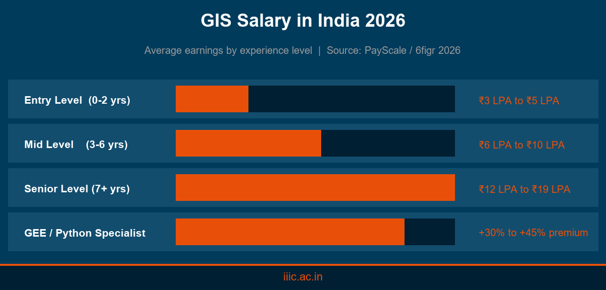
| Entry Level (0–2 years) | ₹3 LPA to ₹5 LPA |
| Mid Level (3–6 years) | ₹6 LPA to ₹10 LPA |
| Senior Level (7+ years) | ₹12 LPA to ₹19 LPA |
Specialists with advanced skills in Python scripting for GIS or Google Earth Engine earn 30 to 45 percent more than general GIS operators at the same experience level. Government roles at ISRO and affiliated agencies offer structured pay scales alongside job security and career progression paths.
Who Can Pursue a GIS Career? Eligibility and Qualifications
You do not need a dedicated GIS degree to enter the field. Many successful GIS professionals in India come from civil engineering, geography, environmental science, and architecture backgrounds. Common eligibility profiles accepted by professional GIS programs include:
- Bachelor’s degree in Science (Physics, Mathematics, or Geography)
- B.Tech or BE in Civil Engineering
- Diploma in Civil Engineering
- BA in Geography
A focused geographic information system course in India is the fastest route to industry readiness. Short-duration diploma and advanced diploma programs combine GIS fundamentals, remote sensing, Python programming, spatial analysis, and a structured internship to prepare you for real-world roles in six to twelve months.
Key Skills That Make You Hireable as a GIS Professional
Beyond a course qualification, employers in infrastructure and technology look for a specific combination of technical and analytical skills:
- GIS Software Proficiency: ArcGIS, QGIS, and Google Earth Engine are the most widely used platforms across Indian organisations.
- Remote Sensing: Interpretation of satellite and drone imagery for land use, disaster mapping, and environmental studies.
- Python Programming: Automating spatial workflows and processing large geospatial datasets efficiently.
- Data Quality Management: Validating, cleaning, and documenting spatial databases for project-level accuracy.
- Spatial Analysis: Applying overlay, buffer, and network analysis to support decisions in urban and infrastructure projects.
Start Your GIS Career in India Today
A GIS career in India offers a strong combination of sector diversity, competitive salaries, and long-term demand backed by government and private investment in geospatial technology. The field is open to graduates from multiple backgrounds, and a quality geographic information system course in India can get you job-ready within six months.
If you are a civil engineering graduate, science student, or geography graduate looking to build a practical, placement-focused GIS career, explore the Advanced Diploma in GIS at IIIC. A six-month program built on 75 percent practical training, GIS and remote sensing software, Python programming, and a two-month industry internship backed by a government-established institution.
Apply now at IIIC and take the first step toward a career in geospatial technology.
Frequently Asked Questions
What is the scope of GIS in India?
GIS scope in India is broad and growing. Sectors including infrastructure, urban planning, agriculture, defence, and environmental management actively hire GIS professionals. India’s geospatial economy is projected to reach ₹63,000 crore by 2025–26, signalling strong long-term demand.
What is the salary of a GIS professional in India?
Entry-level GIS professionals in India typically earn ₹3 to ₹5 LPA. Mid-level professionals with three to six years of experience earn ₹6 to ₹10 LPA. Senior GIS specialists with Python or Google Earth Engine skills can earn ₹12 to ₹19 LPA.
Which course is best for a GIS career in India?
A focused advanced diploma in GIS is considered the most practical route. Programs that cover GIS fundamentals, remote sensing, Python, spatial analysis, and include a structured internship prepare students for industry roles within six months.
What does a GIS analyst do?
A GIS analyst collects, processes, and interprets spatial data to support decisions in infrastructure, urban planning, and environmental management. Daily tasks include mapping, data quality checks, spatial analysis, and reporting insights from satellite or survey data.
Is a GIS career good in India in 2026?
Yes. GIS demand in India is supported by government programs including Smart Cities, Digital India, and the National Geospatial Policy. Private sector growth in telecom, logistics, and real estate further strengthens career outlook for trained GIS professionals.
What qualifications are needed to study GIS in India?
Most GIS diploma programs require a B.Sc., B.Tech or BE in Civil Engineering, Diploma in Civil Engineering, or a BA in Geography as minimum eligibility. A background in spatial science or technical drawing is helpful but not always mandatory.
How long does a GIS course take in India?
Advanced diploma programs typically run for six months, including an internship phase. Postgraduate diploma programs can take one year. Short certificate courses covering specific GIS tools can be completed in four to twelve weeks depending on the provider.
What software should I learn for a GIS career in India?
ArcGIS and QGIS are the most widely used GIS platforms in Indian organisations. Google Earth Engine is increasingly sought for remote sensing work. Python scripting for spatial analysis is a high-value skill that significantly improves salary prospects.
Can civil engineers pursue a GIS career in India?
Yes. Civil engineering graduates are well-suited for GIS careers because of their understanding of spatial concepts, surveying, and infrastructure planning. Many GIS roles in India specifically target civil engineers for utility mapping, road planning, and site analysis.
Where can I study GIS in Kerala?
IIIC (Indian Institute of Infrastructure and Construction) in Kollam, Kerala, offers an Advanced Diploma in GIS, a six-month program covering GIS, remote sensing, Python, and spatial analysis with a two-month industry internship and placement support.