

GIS Training Institutes in Kerala: What to Look For Before You Enrol

You are kindly requested to fill out this form and select the course at IIIC that interests you so that we may get in touch with you as soon as admissions are open.
Picking a gis training institute kerala option is a different problem from picking a modelling course, and the checks that matter are different too. Spatial data work lives or dies on data quality, field capture and analysis discipline rather than on drawing skill. This guide sets out what to ask a provider before you enrol, and what a good answer to each question actually sounds like.
Key Takeaways
- Ask about field capture, not just desktop software, because a practitioner who has never collected data misjudges what it can support.
- Check that both commercial and open source platforms are covered, since employers are split between them and loyalty to one narrows your options.
- Data discipline is the real curriculum: projections, coordinate systems, topology and attribute quality decide whether analysis is usable.
- Demand programme level placement figures and ask which employers hire spatial data graduates specifically rather than the institute overall.
Check One: Does the Course Get You Into the Field
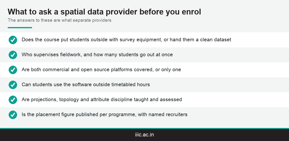
This is the question that separates a genuine spatial data programme from a software class, and it is the first thing to ask. Does the course put you outside with equipment, or does it hand you a clean dataset somebody else collected?
The distinction matters because real data is messy. Coordinates drift, features are obscured, boundaries are disputed and instruments have limits. A practitioner who has never collected data tends to over trust it, which is the most expensive habit in the discipline.
Field capture also teaches accuracy honesty. Knowing what precision an instrument actually delivers, and therefore what conclusions a dataset can and cannot support, is a judgement that only develops through use.
Ask what equipment students use and how often. IIIC runs the advanced survey lab on its Kollam campus, and also offers the advanced surveying certificate as a shorter route into the same skill base.
The capture side extends beyond ground survey. Satellite and aerial imagery build many of the layers analysis then works on, and IIIC publishes its remote sensing programme guide covering that discipline specifically.
If a provider cannot describe a single field exercise a student completes, treat the course as a desktop introduction. That may be all you need, but it should be priced and described as such rather than as professional training.
IIIC puts the hands on share of its training at roughly seventy five percent across the institute, which gives you a number to compare other providers against instead of a vague reassurance about practical learning.
One more question is worth asking about fieldwork specifically: who supervises it, and how many students go out at once. A field exercise where thirty people watch one person operate an instrument is a demonstration rather than training, and the difference is easy to establish before you enrol.
Check Two: Which Software, and Whether You Are Locked to One
The spatial data software market is genuinely split, which makes this a more consequential question here than in most disciplines. Employers use different platforms, and being fluent in only one narrows where you can apply.
On the commercial side, platforms such as ArcGIS dominate government and large enterprise work, and familiarity with that environment is what many public sector employers screen for first.
On the open source side, QGIS is widely used by consultancies, research groups and smaller firms, partly on cost and partly because it handles certain workflows more flexibly.
A good programme covers both, and more importantly teaches the concepts underneath so that moving between them is a matter of interface rather than of relearning the discipline from the beginning.
Ask a specific question: can students use the software outside timetabled hours. Spatial analysis is learned by repetition on messy data, and access limits directly limit how much skill a course can build.
Ask about scripting too. Repetitive geoprocessing is increasingly automated, and even a basic ability to script a workflow separates a graduate who can handle volume from one who processes everything by hand.
A provider who answers all of this with a single product name is selling you a tool course. That has value, but it is not the same purchase as a qualification in the discipline, and the price should reflect the difference.
Data formats deserve a question of their own. Being comfortable moving between vector and raster data, and between the common exchange formats each platform prefers, is what stops a graduate from being stuck the first time a client sends a file their course never mentioned.
Check Three: Whether Data Discipline Is Actually Taught
This is the least visible item on the checklist and the most important. Most spatial projects spend more time preparing data than analysing it, and providers rarely advertise the unglamorous half of the work.
Coordinate systems and projections come first. Layers built on different references do not line up, and a practitioner who cannot diagnose that produces maps that look convincing and are quietly wrong by tens of metres.
Topology is next: whether polygons close, whether networks connect, whether boundaries share edges cleanly. Analysis run over broken topology returns numbers that no one notices are meaningless until a decision has already been made on them.
Attribute discipline is the third piece. Consistent naming, controlled values and documented sources are what make a dataset usable by somebody other than the person who built it, which is the whole point in an organisation.
Metadata and provenance close the set. Knowing where a layer came from, when, at what accuracy and under what licence is what lets an organisation rely on it rather than rebuild it every time somebody new inherits the work.
Ask how these are assessed. A programme that assesses on a built dataset and a written account of its limitations is teaching the discipline. One that assesses on a finished map may only be teaching cartography.
For context on where this leads professionally, IIIC publishes the GIS career guide, which covers scope and progression in more depth than a selection checklist has room for.
Check Four: Accreditation, Employers and Verifiable Outcomes
The final checks are the same ones you would apply to any training provider, but the employer mix in this field makes one of them more pointed than usual.
On accreditation, ask which national or sector skill body the institute is affiliated with and confirm it independently. IIIC is affiliated with the National Skill Development Corporation across thirteen sectors, listed on IIIC’s accreditation and affiliation page.
That matters more here than in some disciplines, because a large share of spatial data employment sits with government departments, utilities and public agencies, where recognised credentials are often a formal requirement rather than a preference.
On outcomes, insist on programme level figures. IIIC reports a hundred percent placement rate for its GIS and GPS certificate programme, which is the strongest published figure across the institute, alongside ninety two percent for urban planning design and management.
Named recruiters are the next question. IIIC lists ESRI India among more than fifty recruiting organisations on the placement outcomes page, and a specialist spatial employer on that list is a more meaningful signal than a long list of general construction firms.
Ask about supervised project experience as well. The spatial data internship is listed separately at IIIC, and internship output is what a first employer actually interviews against.
Take all four checks to every provider you shortlist. The value of the list is that it is comparable, and a provider unwilling to answer in writing has told you something useful without meaning to.
Conclusion
Judging a gis training institute kerala option properly means asking about the parts providers do not advertise: field capture with real equipment, coverage of both commercial and open source platforms, and whether projections, topology and attribute discipline are actually taught and assessed. Add a verifiable skill body affiliation and programme level placement figures, and you have a comparison that survives the marketing. Ask IIIC these questions directly on 8078980000, or apply online at iiic.ac.in.
Related Reading
Frequently Asked Questions
What should I look for in a GIS training institute in Kerala?
Ask about field capture with real equipment, coverage of both commercial and open source platforms, whether data discipline is taught and assessed, and whether placement figures are published at programme level rather than institute wide.
Do I need field survey experience for spatial data work?
It helps considerably. A practitioner who has collected data understands its limits and does not over trust it, which is the most expensive habit in this discipline and the hardest one to unlearn later in a career.
Should I learn commercial or open source software?
Both. Government and large enterprise work leans commercial, while consultancies and research groups often use open source. A good programme teaches the concepts underneath so switching between them is an interface question, not a relearning one.
What is the most underrated part of the curriculum?
Data discipline. Coordinate systems, projections, topology, attribute consistency and provenance together decide whether any analysis is usable at all, and most real projects spend considerably more time on that preparation than on the analysis itself.
Which IIIC programme covers spatial data?
IIIC teaches it at the six month Advanced Diploma tier. The current terms are on the AD GIS programme page, and a shorter surveying certificate is also available for applicants who want a first step.
What placement outcomes does IIIC report for this field?
IIIC reports a hundred percent placement for its GIS and GPS certificate programme, the strongest published figure anywhere across the institute, and it lists ESRI India among more than fifty named recruiting organisations spanning all of its programmes.
Who employs spatial data graduates in Kerala?
Government departments, utilities, planning bodies, surveying firms and infrastructure consultancies are the main employers of these graduates. That mix is why a recognised skill body affiliation matters more here than in some other disciplines you might compare.
Is an internship worth doing alongside the programme?
Yes. Supervised project experience is what a first employer interviews against, and IIIC lists a separate spatial data internship. Ask the admissions team how it is allocated and what a student typically produces during it.
How long does the programme take and what does it require?
The Advanced Diploma runs six months, with eligibility built around a relevant degree or diploma plus roughly three years of relevant work experience. Intake is capped at forty seats per programme right across that tier.
Can I see the labs before I apply?
Yes, and it is worth doing. The campus runs an advanced survey lab among its workshops, and you can arrange a visit through the enquiry form before committing to an intake cycle or paying anything.